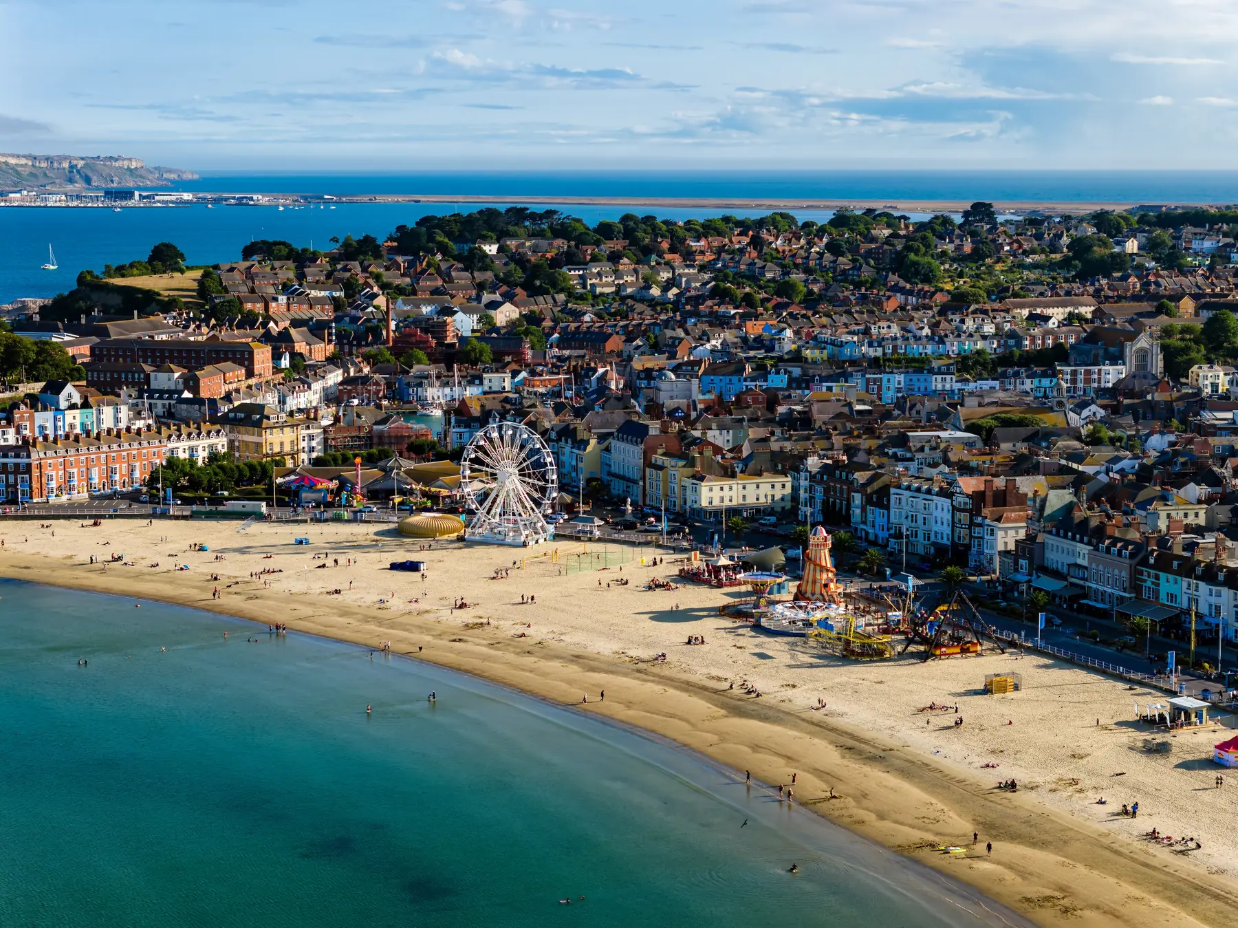
Weymouth sits roughly halfway along the Jurassic Coast, England’s only natural World Heritage Site, and it has an unusual amount of walking within a few kilometres: a Georgian seafront, a Victorian fort on a headland, a disused railway path running south, an eighteen-mile shingle bank with a lagoon behind it, and a limestone island joined to the mainland by the beach.
Go east along the coast and you get chalk cliffs, coves and Durdle Door. Go west and you get Chesil, the Fleet and the West Dorset heritage coast. Go inland and you get downland and the largest Iron Age hillfort in Britain.
Distances are from the town centre.
Weymouth’s seafront is a curve of Georgian and Regency terraces facing a wide, gently shelving beach, and walking its length is the town’s default hour. King George III’s statue stands at the northern end — he came here to bathe from 1789 and made the place fashionable, which is the reason for all the Georgian frontage behind you.
Greenhill Gardens at the far end climb from the promenade with a view back over the bay, and Alexandra Gardens sit at the harbour end.
The harbour is the best part of Weymouth: a working quay with a seventeenth-century waterfront, fishing boats, pleasure craft and a lifting bridge, lined with pubs and restaurants on both sides.
Follow the southern quay round and up onto the Nothe Peninsula, where Nothe Fort — a Victorian fort of the 1860s, built to defend the harbour and now run largely by volunteers — stands at the point. The Nothe Gardens below it are free, wooded and quiet, with the best views in the town: across the harbour one way and out to Portland the other.
The circuit from the town round the harbour, up to the Nothe and back is about four kilometres and takes ninety minutes.
A disused railway line, now a level surfaced path, running about three kilometres from the town centre south to Ferrybridge at the start of the Portland causeway. It passes through cuttings and a tunnel, with access down to Sandsfoot Castle — one of Henry VIII’s artillery forts of 1539–41, now a picturesque ruin in a small public garden above the sea.
Flat, traffic-free and the easiest walk in Weymouth. It links to the coast path at both ends.
At Ferrybridge the extraordinary geography begins. Chesil Beach is an eighteen-mile shingle barrier running north-west from Portland to West Bay, and behind it lies the Fleet — a shallow tidal lagoon, the largest in Britain, and an internationally important site for wildfowl.
The beach itself is walkable but hard going: the pebbles are graded by size along its length, famously, so that fishermen landing in fog could tell where they were. The Fleet path on the landward side is easier and better for birds.
There is a visitor centre at Ferrybridge.
Cross the causeway and the character changes completely: a limestone island four miles long rising to 150 metres, quarried for centuries for the stone that built St Paul’s Cathedral and half of London.
Portland Bill, at the southern tip, has a red and white lighthouse, the Pulpit Rock stack, and — offshore — the Portland Race, one of the most dangerous tidal races in Britain, which on a spring tide is visibly a wall of standing water.
Tout Quarry on the western side is a sculpture park in a disused quarry, free and strange. Church Ope Cove on the east has Rufus Castle above it. The coast path runs right round the island, about thirteen kilometres, and it is one of the best days on the Jurassic Coast.
Six kilometres east, cut into the chalk above the village of Osmington, is a figure of George III on horseback — the only chalk hill figure in Britain of a mounted king, carved in 1808. The walk up to it from the village gives the whole of Weymouth Bay.
The coast path east from Weymouth runs over White Nothe, one of the highest points on the south coast, past Ringstead Bay and down to Durdle Door — the limestone arch that is the most photographed thing in Dorset — and Lulworth Cove, a near-circular bay eaten out of the rock.
It is around eighteen kilometres from Weymouth to Lulworth and it is a serious day with a lot of climbing. Most people drive or bus to Lulworth and walk the section from there.
Note: the coast path east of Lulworth crosses the Lulworth military range and is closed when firing is taking place. Times are published.
Maiden Castle, twelve kilometres north near Dorchester, is the largest Iron Age hillfort in Britain — enormous multiple ramparts enclosing a hilltop, free and open, and a genuinely astonishing piece of earthwork.
Radipole Lake and Lodmoor, both RSPB reserves within the town, have boardwalks and hides and are excellent for birds — Radipole is one of very few nature reserves with a town-centre bus stop.
The Dorset National Landscape and the downland north of the town give quiet chalk walking with almost nobody on it.
Buses. The open-top 501 runs to Portland Bill in season; the X53 runs west along the Jurassic Coast; the X54 goes east to Poole via Wool and Wareham. All three make one-way coast walks possible.
Trains run to Dorchester, Poole, Bournemouth and London Waterloo, and to Yeovil and Bristol on the Heart of Wessex line.
Firing ranges. The Lulworth range closes the coast path east of Lulworth Cove when in use.
Chesil Beach is hard walking and the seaward side has a steep shelf and dangerous undertow. Do not swim off it.
Tides matter along the whole of this coast, and several of the beaches below the cliffs are cut off.
Spring brings the chalk downland flowers and the seabirds back to the cliffs, and the coast path is dry and empty before Easter. It is the best season for the Fleet and the Swannery, where the cygnets hatch in May and June.
Summer fills the beaches and Lulworth, and leaves the western coast towards Chesil and the inland downland surprisingly quiet.
Autumn is the best walking of the year — clear air, warm sea, empty paths, and the migrating birds coming through Portland Bill, which is one of the finest bird observatories in Britain.
Winter is when the coast shows what it is. A south-westerly gale into Chesil Beach and the Portland Race running on a spring tide are among the more impressive free spectacles in England, watched from a safe distance.
You are walking on the reason the coast is a World Heritage Site. The rocks run in order from west to east — Triassic at Exmouth, Jurassic through Lyme and Charmouth, Cretaceous towards Purbeck — so that walking the coast is walking forward through 185 million years.
Around Weymouth the good hunting is west at Charmouth and Lyme Regis, where the Lias cliffs shed ammonites and belemnites constantly and the beaches are worked over daily. Portland’s own stone is full of fossils, including a fossil forest of Jurassic tree stumps at the eastern end.
The rule everywhere is the same: collect from the beach, never from the cliff face, and keep well back from the cliffs themselves, which are actively eroding and fall without warning.
The harbour and the Nothe for ninety minutes; the Rodwell Trail for a flat hour; Portland Bill for the best day.
Yes, along the Rodwell Trail to Ferrybridge and across the causeway, though it is a long road walk. The 501 bus is the easier option.
About eighteen kilometres east by the coast path, or twenty-five minutes by road to the Lulworth car park.
An eighteen-mile shingle barrier running from Portland to West Bay, with the Fleet lagoon behind it. Walkable but hard going, and not safe to swim from.
The Rodwell Trail, the Esplanade and the boardwalks at Radipole and Lodmoor.